
Weather: Where will the storms ‘hit’

The weather changes rapidly in the next few hours, according to EMSwhich has updated the emergency report issued on Saturday.
According to the updated newsletter, the weather is expected to deteriorate on Sunday afternoon (06-04-2025) with local rains and thunderstorms, a significant drop in temperature and heavy snowfall mainly in the mountainous and semi-mountainous Macedonia and Thrace. The change in the weather will start in the northern country.
Weather: More detailed:
1. On Sunday (06-04-2025) in eastern Macedonia and Thrace in the afternoon and evening hours and in the evening in the northeast Aegean (Limnos area).
2. On Monday (07-04-2025) until noon on the islands of the Eastern Aegean.
1. From Sunday night (06-04-2025) to Monday (07-04-2025) and until noon Monday in the mountains and semi-mountains of Thrace and Macedonia (areas with an altitude of 400 meters or more) and locally in the prefecture of Evros and in lowland.
2. Monday morning (07-04-2025) in the mountains of Epirus and Thessaly.
D. Feeling dropping the temperature on Sunday afternoon in Macedonia and Thrace and gradually on Monday and Tuesday in central and southern Greece. Frost in the northern country on Monday night (07-04-2025) and inside all of mainland Greece in the morning and evening hours of Tuesday and Wednesday and in the early hours of Thursday.
According to the forecasts of meteo.gr / National Observatory of Athens, cold air masses will affect our country on Sunday night 06/04, resulting in a significant drop in temperature, which will be accompanied by snowfall in areas mainly in northern Greece.
Snowfalls are expected on Sunday night 06/04 in the northern mountains and during the night at dawn on Monday 07/04 in the semi -mountainous, but also temporarily in areas with lower altitude of Macedonia and Thrace.
From the early hours of Monday 07/04 snowfall will also occur in the mountainous and semi -mountainous sections of central Greece. Still, rain will occur in most of the country and sporadic thunderstorms in the northeast, and the phenomena will begin to weaken on Monday afternoon 07/04.
Dip in temperature of 10 degrees Celsius
In addition, the temperature drop, which is expected to be around 10 ° C, will become more noticeable on Monday 07/04 in the central and northern parts of the country. The rest of Greece will also be affected by Tuesday 08/04, while the frost will insist on many areas of the northern country, mainly in the morning and evening hours, until Friday 11/04.
Still on Sunday night 06/04, there is a reinforcement of the north that will have tensions of 4 to 6 and local 7 beaufort in the seas.
The following prognostic maps are captured in blue shades, the estimated distribution of rainfall and with pink shades or estimated distribution of snowfall. The maps are mentioned in the intervals Sunday 06/04, 21:00 – Monday 07/04, 00:00 and Monday 07/04, 03:00 – 06:00.
Rainfall/snowfall map on Sunday 06/04, 21:00 – Monday 07/04, 00:00
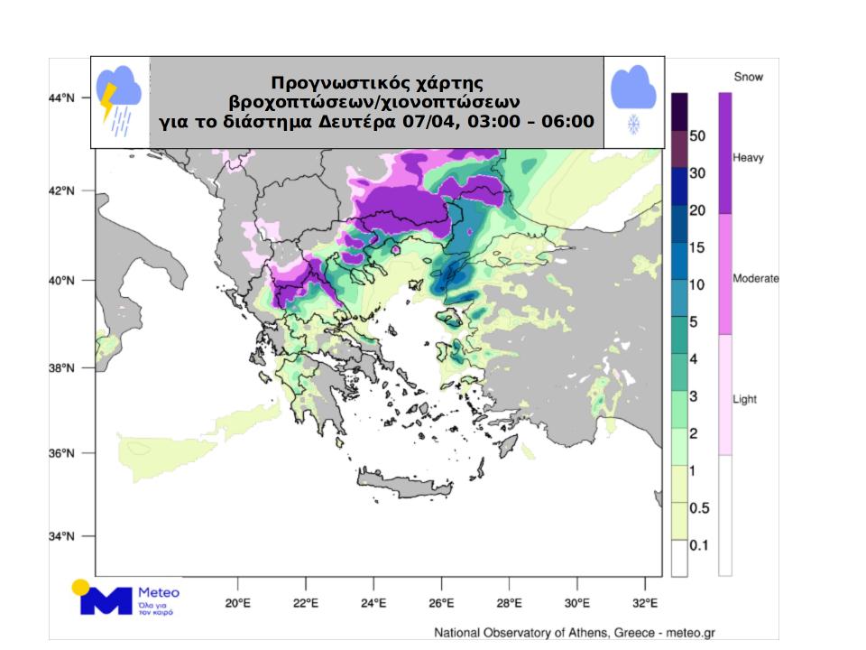
Rainfall/snowfall map on Monday 07/04, 03:00 – 06:00.


