
Weather: ‘Thermal Dome’ brings 39s with prolonged heat – how much will it hold

Strong wave of heat, we are reserved by the weather In the following days, with the temperature flirting with 40 degrees Celsius. According to meteorologist George Tsatrafyllia and his latest post on Facebook, « thermal dome brings 39ar and prolonged heat », since Wednesday on several parts of the country.
The thermal dome is expected to prevail for at least 7 days, according to the meteorologist. He explains that this heat wave is expected to have outbreaks and its duration seems to continue to continue until the second week of June.
Thermal dome in the country – Facebook/ George Tsatrafyllias
Indicatively the course of temperature in 10 cities
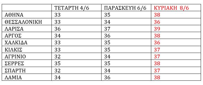
Table from Facebook/ George Tsatrafyllias
« Thermal dome brings 39s and prolonged heat! »
In detail, Mr Tsatrafyllias states: « Thermal dome brings 39s and prolonged heat! Such a « thermal dome » due to the relatively high pressures that will occur in our area is expected to prevail in Greece at least at least 7 days, causing a significant rise in temperature.
We will understand the rise in temperature from Wednesday and then to the hot areas of Thessaly, Central Macedonia, Fthiotida, Boeotia, Aitoloakarnania and Peloponnese.
This wave is expected to have outbreaks, and its duration seems to be approaching the second week of June. Attention to the increased risk of fire! Indicatively, the temperature course in 10 cities is shown in the table below as well as the phenomenon of the « thermal dome » in the pictures below! «
Heat in the next few days – The EMY prognosis
Based on the EMY prognosis, a temperature rise is expected in the coming days, which will be higher than normal on Thursday.
PROPERTY FOR TURTY TUE 03-06-2025
Generally cloudy weather. Few local clouds will develop in the afternoon – afternoon in the mountainous continents with a low probability of local rainstorms.
The winds will blow west northwest 3 to 5 and in the central and southern sea local 6 beaufort.
Temperature will make a slight rise and will reach the island of Greece 28 to 30 degrees, on their continents 30 to 32 and in the central continents local 33 degrees Celsius.
PROPERTY FOR WEDNESDAY 04-06-2025
Generally cloudy weather. Few local clouds will develop in the midday – afternoon hours in the mountainous continents with the possibility of local rainstorms.
The winds will blow from northern directions 3 to 4, in seas 4 to 5 and in the central and southern Aegean local 6 beaufort.
The temperature will rise slightly.
PROPERTY FOR THURSDAY 05-06-2025
Generally cloudy weather, while local clouds will develop mainly in the mountainous continents in the afternoon – afternoon with local rainstorms.
The winds will blow from northern directions 3 to 4, in seas 4 to 5 and in the central and northern Aegean local 6 beaufort.
The temperature at a slight further rise and will range to levels higher than normal by 3 to 5 degrees Celsius.
PROPERTY FOR THE FREE 06-06-2025
Generally cloudy weather with few local clouds in the midday – afternoon hours on the mainland where local rainstorms will occur in the mountains.
The winds will blow from northern directions 3 to 5 and in the Aegean local 6 and temporary 7 beaufort.
The temperature will not make a significant change.


