Weather: Over 6,000 lightnings – in which area did most of the rain fall

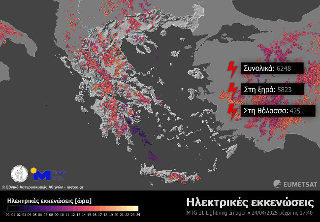
More than 6,000 thunderstorms were recorded across the country on Thursday and mainly in the continental sections and Crete, according to data from the Athens National Observatory Meteo.gr.
According to the Athens National Observatory of Automatic Meteorological Stations- meteo.gr, by 17:30 on Thursday, the highest rainfall was recorded at the Kilkis Isoma Station and was equal to 33.4 mm, while local rainfall was located at 26. mm.
Data analysis by the European Meteosat-12 Meteorological Satellite and the Lightning Imager (Li) body has shown that more than 6,000 electrical evacuations have been recorded by 17:40 on Thursday.
It is noted that as electrical evacuations we define all of those that include lightning (discharges between clouds and soil), electrical discharges between clouds and electrical discharges between clouds and the surrounding air.
See the map with the lightning
The weather on Friday
Fridays are forecast temporarily increased with local rains and sporadic thunderstorms initially in the western country and the central continents and from the noon hours and the rest of the continents, Euboea, the Cyclades, Crete and the Dodecanese.
Thunderstorms locally in the central continents may also be accompanied by temporary hailstorms. At night the phenomena in most areas will stop.
The winds will blow 3 to 4 and south west to 5 beaufort.
The temperature will not make a significant change and will reach most areas of 20 to 22 degrees Celsius.


