View from the sky to navigate the ice waters

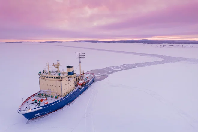
All warmer Arctic is expected to grow naval traffic, which is why researchers, based on satellite predictions, help seafarers plan to plan a safer navigation between sea ice and ice mountains.
Nicolas Dubreuila veteran of polar expeditions with more than thirty years of experience in the Arctic, knows firsthand the dangers of navigation throughout the ice maze there. In 2001, while walking on the ice she in Greenland, he fell seriously and injured himself. However, the accident did not distract him from the Arctic, on the contrary, he only attracted him even more. “I adopted the Greenland motto that they were just time and ice. I said goodbye to my life in France, moved to a village in northern Greenland and learned the traditional lifestyle here, « he said.
Today, in the village of Kullorsuaq in northern Greenland, he runs an agency that offers expeditions for tourists, film teams and scientists who want to get to know the sea ice and icebergs in more detail. At one of his latest adventures, Dubreuil trained local hunters to install probes with GPS signals on the icebergs. Their unique skills and the knowledge of ice are to help the team led by another Frenchman, Laurent Bertinomathematician from the Center for Environmental and Gorn Nansen (Nersc) in Bergen, Norway.
Warns of the icy mountains
The Arctic is changing significantly due to climate change. Due to increasing temperatures, there is less and less sea ice, ice is thinner, glaciers are breaking, and more and more icebergs are forming. The Arctic Summer Sea LED shrinks for a good 12 percent to a decade compared to the 1981-2010 average. Ships are most at risk in the spring and summer when ice sheets break and move. At that time, dangerous smaller plates of floating ice are formed.
The NERSC Center in partnership with the Norwegian Meteorological Institute, the European Center for Middle -term weather forecasts, the organization Mercator Ocean International, the Italian National Research Council, the Istanbul Technical University and the Danish Meteorological Institute coordinates the international survey ACCIBERG. The team of the project is accompanied by sea LEDs and icebergs in the Arctic with the help of satellite data of the European Copernicus network. These satellites also provide information about the oceans that are included in the models of the forecast of the movement of icebergs.
The aim of the project is to significantly improve the accuracy and reliability of navigation information for Arctic navigation by developing two freely accessible prototypes for prediction. One provides sea ice forecast from a few days to several months in advance with a marked rate of certainty, while the other allows you to calculate the forecast of the iceberg ferry on request. The forecast model will be improved, among other things, with the help of GPS transmitters on the iceberg.
One of the biggest challenges is to provide timely and accurate predictions to ships at sea. Currently, teams from land to ships send image files by email – the process is quite awkward as the Internet connectivity in remote Arctic waters is poor. “The only information that the crew has on board is two or three days old. This one is also useful, but the situation can change quickly, as security depends on whether the crew has time and knowledge to interpret photography, « explained Bertino.
Expansion of maritime trails
The project team also hopes that by improving the probability forecasting, it will allow for a simpler risk assessment and provide longer periods for safe navigation. The project is carried out in collaboration with end users such as Norway and Greenland Led Exploration Service to refine and test these technologies as much as possible.
Keld Qvistgaard He is a senior expert on LED at the Greenland Led Exploration Service, a special department of the Danish Meteorological Institute who monitors and analyzes the state of sea ice near Greenland. “There are more and more shipping, and user needs and requirements are changing. There is a great need to improve Technologies for monitoring and forecasting ice movement, ”he explained. In the last decade, according to the Arctic Council, shipping has increased by 37 percent in this part of the world, and projections show further growth by 2050, as new paths are opening with ice melting. Three crossings – northwestern passage (past Greenland and Canada), North Sea Route (past Russia) and transpolar sea route (past Iceland) – allow for a potentially faster and more cost -effective freight transport.
However, navigation by Arctic is still insidious. Despite the help of icebreakers, giant steel hull ships made to break through the ice, unexpected circumstances can be very dangerous. In November 2021, due to unusual weather in the East Siberian sea, the sea began to freeze earlier. More than twenty ships remained trapped in thick ice, and the rescue operation was long and expensive. “The Arctic navigation season is much longer today than it was twenty years ago. But navigation is also much more changing, « said Bertino.
Navigating toward the future
In addition to improving Copernicus services for maritime and climate change, the Acciberg project also develops new open source prognosis software. In the future, these forecasts, in collaboration with Copernicus, could be included in digital navigation systems to further improve safety in this polar area. The center, officially presented in October 2023, is a centralized platform that enables access to a wide range of data and information about the Arctic and is intended to support decisions based on evidence and sustainable management practices.
Improved forecasts, according to Bertin, are not only beneficial for commercial shipping: “It’s not just money. It is also about supporting people who live and work in the Arctic. «
Similarly, his compatriot Niko Dubreuil me. In Greenland, where he lives, the moving icebergs poses a real risk to the local community. That is why they are happy to actively contribute to the project by installing transmitters on the icebergs. “The project is not just about technology, it is also people living in these places, scientists who are trying to make it easier to navigate, but also tourists who learn about the importance of this environment. We are connected by a common effort. «
––-
The research mentioned in the article are funded under the EU Horizon program. The article was originally published in a magazine HorizonEU magazine for R&D.


