Turkey cuts in the middle of the Aegean

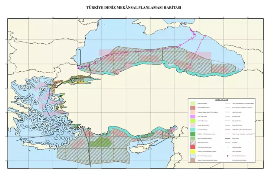
With a leak published front page in the pro -government newspaper Milliyet Turkey has tried to prevent Greece’s announcement of maritime spatial planning, with Ankara announcing its intention to submit its own spatial planning maps, based on the blue homeland.
In Milliyet’s reports « Turkey has completed the study of marine spatial planning: the blue homeland is deepened », he notes that it is ready « a scientific map designing Turkey’s borders with Greece in the Aegean ».
Turkey cuts in the middle of the Aegean
According to the report, « in the Aegean Sea, where there are many differences between Greece and Turkey, the midline between the continental coasts was taken as a border. »
As Milliyet argues, « it was reported that the map of the blue homeland is not a formal maritime jurisdiction binding the state and is a scientific and legal study. The next step will be the (so -called) TRNC and its spatial planning. «
According to Milliyet’s report, « Turkey, which closely monitors EU spatial planning studies; it is taking measures to protect its rights in the Aegean and the Mediterranean ».
And he points out that as it became known that « the DMP (DMP) studies that Turkey launched to protect its rights and interests in the surrounding seas, to better evaluate the environmental impacts of its future activities in the seas and for the maximum use of the seas. »
The map is noted that « it was created by the National Maritime Law Center of the University of Ankara (Dehukam), it was prepared according to the EU shipping acquisition. »
The newspaper also hosts a statement by the Director of the University of Ankara Dehukam, Dr. Mustafa Baskara, who argues that « Turkey’s competent bodies have been studying for a long time. As a center, we have also done joint projects with some of our relevant Ministries on this issue. «
According to Baskara, « When we look at the Mediterranean, it is compatible with the agreement we signed with the TRNC (SA as Turkey calls occupied Cyprus) in 2011. Again, in the rest of the Eastern Mediterranean, the coordinates of which were determined by the Libyan Agreement in 2019. Our borders. The border that our state has declared to the UN have been defined as an external border. «
« The midline between the main territories in the Aegean has been taken as a border, » Baskara said, among other things, arguing that « we have defined the external borders of the Turkish planning planning study based on the midline between Turkey and Greece in accordance with the basic rules of international naval laws. » Meaning the midline from the continental coasts of the two countries, as according to Turkey the islands are not entitled to marine zones.
He states that « this study is a specific indicator of Turkey’s efforts to build a scientific vision of the vision of the Blue Homeland, aware of the economic potential, environmental values and the geopolitical importance of the seas that surround Turkey. »
Turkey with these maps is trying to once again declare its maximalist positions on the ideology of the blue homeland and the illegal Turkolibyan memorandum, with its objections including half the Aegean. Positions that have not yet allowed the substantive dialogue on the issue of marine zones with Greece.


:format(webp)/s3/static.nrc.nl/bvhw/files/2019/08/web-1708zatwongjpg.jpg)