
Macedonia and the Macedonian ethnic substrate from antiquity to this day are different and separate from other ethnicities

Macedonia as something separately appears on more old geographical maps that cover different historical periods. Among the oldest geographical maps of which Macedonia can be seen are the so -called. Ptolemy’s cards, ancient cards based on the work of Claudius Ptolemy (2nd century AD), which were later reproduced in medieval and Renaissance cartography. Among the older geographical maps where the name Macedonia and its main roads can be observed is the Roman Pintzer Map, which originated in the 4th century AD. During the Renaissance, especially during the 15th and 16th centuries, Macedonia appears in several Renaissance maps, such as that of Nikola Sofia. During the 19th century and early 20th century, several geographical maps showed by Macedonia, including those showing its territorial changes
The name Macedonia has deep historical roots, dating back to thousands of years. And the Macedonian substrate too.
The name Macedonia often appears on the old geographical maps because it was the name of the ancient kingdom that played a significant role in history, especially during the reign of Alexander the Great in the 4th century BC. The Macedonian state has spread to huge territories, influencing cultures from Europe to India, which has strengthened its place in historical records. Cartographers often used names based on classical sources, political divisions or regional significance, making Macedonia constantly appearing on historical maps – even when the borders changed over time.
Macedonia as something separately appears on more old geographical maps that cover different historical periods. Among the oldest geographical maps of which Macedonia can be seen are the so -called. Ptolemy’s cards, ancient cards based on the work of Claudius Ptolemy (2nd century AD), which were later reproduced in medieval and Renaissance cartography. Claudius Ptolemy is a turning point in the study of geography and the origin of cartography. He lived in the 2nd century of our era and collected a large number of geographical data he published in his work « Geography », a work that shaped the way people made cards for centuries. Based on the work Geography, the world map of Ptolemy was created.
Among the older geographical maps where the name Macedonia and its main roads can be observed is the Roman Pintzer Map, which originated in the 4th century AD. During the Renaissance, especially during the 15th and 16th centuries, Macedonia appears in several Renaissance maps, such as that of Nikola Sofia. During the 19th century and the beginning of the 20th century, several geographical maps showed by Macedonia, including those showing its historical and territorial changes.
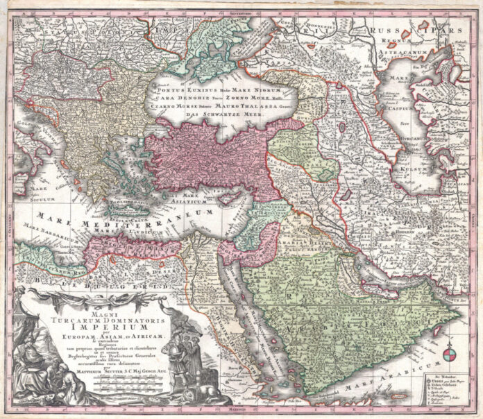
Macedonia is constantly appearing in the geographical and political cards presenting the Ottoman Empire. Cartographers included the Ottoman Empire on the maps because it was a large geopolitical entity with clearly defined boundaries, influencing international relations, trade roads and migration models. Her presence has shaped the course of history, and the cards serve as a record of its wide trial over time. In the aforementioned cards Macedonia is presented as an Ottoman province, but as something separately from Bulgaria or Greece.
Particularly interesting is the spectacular map of the Ottoman Empire from 1730. It includes Turkey, Persia, Egypt and Arabia, published by the important Augsburg card publisher Gerog Mateus Zater. The map shows from Italy to the east to the Caspian Sea, which is fully shown. Includes the Crimea and the Caucasus: Georgia, Cherkazia and Armenia. It extends south to include the entire Arabia and the northern top of the African horn. It is generally correct, with several cartographic anomalies. The dead sea is too much and deformed. A large and non -existent lake appears immediately west of the Nile Delta.
In the lower left quadrant there is a large decorative cartush with a title attributed to Augsburg silver, Abraham Drentvet. It depicts the Ottoman emperor famously dressed and flashy. On the ground in front of him two men bow and offer treasures. Pictures on the right side of the title offer a more elegory reference and include a European holding a globe, a lion, the stick of Asclepius, a shield of jellyfish and spear. Angels with trumpets look from above. In the lower right quadrant, a key appears on the map. Cartographic is similar to the Visher map of 1690 from the same area. Macedonia is also presented on the outstanding geographical map of a large format made in 1794. The map covers from the Gulf of Taranto, Italy, east to Crimea, extends north to Transylvania and Moldova and south to Crete and Cyprus. It includes today’s nations from Greece, Turkey, Cyprus, Bosnia, Croatia, Albania, Serbia, Macedonia, Bulgaria, Hungary, Romania, Bulgaria, Moldova and parts of Italy, Austria and Ukraine. The map offers excellent details, noting cities, roads, geographical features, based on geodetic work originally completed in 1789 by the Imperial Academy of Sciences in St. Petersburg. It has been prepared and published by Lori and Wittl as a plate no. 24 In the edition of Thomas Kichin’s General Atlas since 1797.
It can also be the map of 1719, named as the Empire of the Great Master called Sultan and the Ottoman Emperor of Turks in three parts of the world, as well as a map of the Ottoman Empire published by T. Dunker in Amsterdam in the 18th century. D.


")


/s3/static.nrc.nl/images/gn4/stripped/data132557020-e089ee.jpg "« One could not imagine what sailors had lived through in the war »")