
Insist on severe weather phenomena – the Cyclades were « drowned »

Seriously problems has caused bad weather In the Cyclades, with the most serious of them being found in Paros and Mykonos. Heavy rainfall and hail in places caused major disasters mainly in the Naoussa Paros area. Landscapes, torrents and floods carried tons of loading materials, dragged cars, destroyed property and the island’s road network has become dangerous and in many ways inaccessible. Thirteen people were released and transferred to safe places.
The focus of bad weather was initially from Syros without causing particular problems. A fierce hailstorm, fortunately just a few minutes, « dressed » some streets of the island on white. The phenomena were then shifted to Paros and from there to Mykonos.
Disaster images in Paros
Cyclades Problems – Mykonos was severely struck
The bad weather hit the Cyclades.
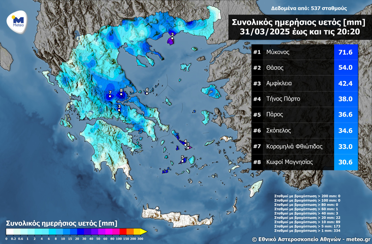
The highest daily rainfall (until 20:20) was recorded at the Athens National Observatory’s automatic meteorological station/meteo.gr located on the island of Winds and is 71.6mm. 65 of these millimeters were recorded in just 2 hours during 17: 10-19: 10 pm Monday afternoon.
On the island he sounded in 112, inviting citizens not to move their cars on the island’s road network due to bad weather. There was a strong hailstorm in the country, and the hail followed heavy rainfall, causing houses to flood in the alleys and creating torrents drilling cars. Residents « must remain in their homes as long as the phenomenon is ongoing. The school units will remain closed on Tuesday, ”the Municipality of Mykonos informed.
The Fire Department Center received a total of 160 calls. Specifically, there were 100 calls to the island of Mykonos, and so far five water pumps have been made. Sixty are the calls in Paros, and so far eight water pumps have been made.
Another problem with the bad weather that swept the Cyclades was faced by Paros, with bad weather hitting the island.
Pictures from Naoussa, one of the most popular tourist villages on the island, were shocking. Dozens of cars were dragged by the rushing waters and ended up in the sea. The Municipality of Paros issued a statement on banning road network until the end of the phenomena.
https://www.youtube.com/watch?v=3yvh4au-hdu
Excellent sos sos
Destruction storm at this time on the island of Paros specifically in Naoussa. pic.twitter.com/rtgpwboxw1
– Forecast Weather Greece (@forecastgreece) March 31, 2025
« The phenomenon that hit us is unprecedented, » Costas Bizas, Mayor of Paros, told Mega. « I have suspended schools and we are on the alert. A new deterioration is expected at night, so we don’t stop. We are waiting for reinforcement with two fire trucks from neighboring Naxos, « he said. On the island at least 30 cars have been dragged.
The risk assessment committee met on Monday. The Commission was convened by the Minister of Climate Crisis and Civil Protection, Yiannis Kefalogiannis and the theme of the meeting was the updated emergency report of dangerous weather events (EDEKFs) of the NMS. According to scientists, until Wednesday, there will be locally heavy rains and thunderstorms from time to time in most areas of the eastern country.
Police forces on the Cyclades is also on guard and the Armed Forces and in particular the management of construction and treatment of natural disasters (DIFFACE) have been placed on alert, upon request.
The helicopter who had left Athens to Paros with 8 firefighters was forced to cancel his mission and returned to Athens due to extreme weather events that made the flight dangerous and will be transported by Naxos 3 vehicles with 6 firefighters.
https://www.youtube.com/watch?v=b3akihketis
On Tuesday 1/4 in the Cyclades there are heavy rains and thunderstorms that will be locally dangerous until the morning. Heavy rains and thunderstorms in the islands of the Eastern Aegean (mainly Samos – Ikaria – Chios), in the Dodecanese, Thessaly and Sporades, until the early morning hours in Attica, until noon in Eastern Solidarity and Evia and Evia and Evia.
According to the director of the National Meteorological Service, Thodoris Kolidas, there will be a thunderstorm zone in the Cyclades and mainly in the northernmost departments that will gradually move east to Samos and Ikaria.
« Imagine an imaginary triangle between Tinos-Andros-Chios-Samos and Ikaria. The thunderstorms will be mainly in the Aegean and will also affect the Dodecanese, ”said Th. Kolidas and called on the inhabitants to be vigilant.
#Breaking #Greece #Mykonos #Grecia
Greece: Islands in the Cyclades, Including Paros Syros and Mykonos, Hit by Heavy Rain and Thunderstorms on Monday
A Red Alert Warning is Issued.
scenes from mykonos#Ultimahora #Flooding #Inundación #Inondation #Flood #Mykonos pic.twitter.com/xtdosskchr
– LW World News (@Loveworld_peopl) March 31, 2025
Message through 112 was sent to residents of Chios, Samos and Ikaria, warning them of severe weather events strongly from now on Tuesday morning, inviting them to be careful in travel.
The EMY’s emergency weather report provides for locally heavy rains and thunderstorms from time to time until Wednesday morning (2/4) in most areas of the eastern country.
A. In the Cyclades until noon Tuesday (1/4) – Righteous Warning – until the morning of Tuesday (1/4).
B. In the islands of the Eastern Aegean (mainly Samos, Ikaria, Chios area) from Monday night (31/3) to Tuesday night (1/4).
C. In Eastern Sterea and Euboea until noon on Tuesday (1/4).
D. In Attica on Monday night (31/3) to Tuesday (1/4).
E. in Thessaly and Sporades from the early hours of Tuesday (1/4) to the evening of the same day.
F. In the Dodecanese from the morning hours of Tuesday (1/4) to the morning hours of Wednesday (2/4).
G. In the West and Southern Crete from the evening of Tuesday (1/4) to the morning hours of Wednesday (2/4).
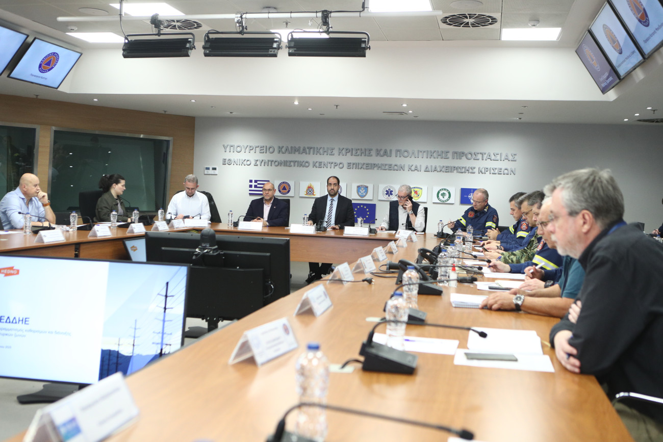
Meeting at the Ministry of Climate Crisis and Civil Protection, under Minister Yiannis Kefalogiannis
- Be sure to keep up to date on radio and television about the evolution of weather. The official sources of information are the National Meteorological Service (EMY) and the General Secretariat for Civil Protection.
- In case of need, call Alternatively: Police 100, Fire Brigade 199, EKAB 166, European Emergency Number 112.
- Place the above -mentioned essential numbers at home if your children are able to use them and make sure they know it.
- Help your children memorize family items such as their adjective, address and phone number of the house.
- Explain to all family members how and when to close electricity, gas and water benefits, how to use the fire extinguisher and how to call for help.
- Get essentials such as first aid box, fire extinguisher, lens and batteries, portable radio etc.
- Take special care for children and the elderly.
Newer elements for heavy rains and thunderstorms foreseen from today to Wednesday morning in most areas of the eastern country
We follow Protection Instructions … pic.twitter.com/n9zs5tkwey
– Civil Protection Gr (@civpro_gr) March 31, 2025
- You are constantly watching on the radio and television the formal warnings or tips.
- Check your home and other assets to record possible damage.
- Find out about the weather and condition of the road network.
- Depending on your destination, consider the type of weather you may encounter (snow, frost, hail, rainfall, etc.).
- Change your travel program to avoid the peak of weather.
- Travel during the day, preferring the central arteries rather than inaccessible and deserted roads.
- Update your relatives about the route you will follow.
- Do not ignore the instructions of the General Secretariat for Civil Protection, the EMY weather reports. and the suggestions of the local authorities, such as traffic, the port, the fire department, etc.
- Check your car status before each move.
- Equip the car with the necessary means of dealing with severe weather phenomena (anti -skid chains, antifreeze liquids, umbrellas, waterproofs, bronze, lens, first aid box, etc.).
- Wear suitable clothes if you are going to move on foot.
- Be careful when walking to avoid injuries due to slippery slippery and sidewalks or due to falling excessive winds or hailstorms.
- Prefer public transport for your commute.
- Stay calm and patient. Panic burdens the situation.
- Facilitate the work of the authorities.
Due to the bad weather, schools in Paros, Mykonos, Rhodes, Kos and Symi will remain closed on Tuesday (01/04).


:format(jpeg):fill(f8f8f8,true)/s3/static.nrc.nl/wp-content/uploads/2019/10/youp5bij3.png "Column | Sparkling cutting back – NRC")

