Earthquake in Mount Athos: The rift that can ‘break up’ with over 7 Richter

Countless earthquakes, greater than 5 Richter, have caused the largest and most dangerous rift in the underwater area of the North Aegean.
Some of them, as happened in January 2022, become sensible to Attica.
It is a primordial rift that faces Mount Athos and has such dynamic, which can even cause an earthquake far greater than 7 Richter.
Such a fierce event will send the coast of the Thermaic tsunami.
160 km long
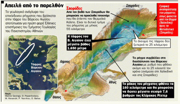
This rift, about 160 km long, was first mapped by a team of scientists led by the then Professor of Geology and Director of the Natural Disaster Laboratory at the University of Athens, Dimitris Papanikolaou and was published in the well -known scientific inspection.
Indeed, from the analysis of the data gathered, Greek scientists had expressed the assessment that the rift could give a destructive earthquake magnitude 7.6 on the Richter scale and a tsunami that would hit the Thermaic Gulf coast.
From Sporades to Lemnos
The rift is 160 kilometers long and extends from Sporades to Lemnos. According to expert scientists’ estimates, it began to be created about 4-5 million years ago.
In the past, the rift caused severe seismic vibrations, resulting in the burglary of the bottom of the bottom of the northern ditch.
Aegean that reaches a depth of up to 1,650 meters.
Today, the two sides on either side of the rift still move either horizontally with each other or vertically each other. The result is a large part of the central and southern Aegean to be pushed to the southwest because of this process.
That is, the rift, that is, contributes to the widening of the North Aegean at a pace that even reaches 25mm a year, between Halkidiki and Sporades.
From Anatolia
This slow -moving geological structure, according to Dimitris Papanikolaou, « is essentially the western extension of the Great Northern Anatolia. »
« The rift is considered quite frightening because if the whole is activated, a particularly large energy will be released, which can cause an earthquake of 7.6 on the Richter scale, » according to Dr. Giannis Papanikolaou Geology, who during the research period was a member of the Benfield Research Center of Natural Disasters at University College, London.
« This does not mean, of course, that we expect such an earthquake in the coming years. All the elements we have worked on show us that such a powerful earthquake could occur every hundreds of years.
In the past, they assumed that the maximum possible size the area could give ranged from 7.2 to 8.5 Richter. Based on today’s data, it is now clear that the maximum size is not expected to exceed 7.6 Richter. «
In three sections
Greek experts found that the rift is divided into three individual sections, each of which can be activated autonomously and « give » an earthquake with a maximum size of 7.1 on the Richter scale. The west of the pieces of the rift, which is about 55 kilometers long, is in the Sporades and its movement is mainly vertical.
In the case of its activation, the rift could cause a displacement of the bottom by two meters and in this case the conditions for the appearance of a tidal wave, a tsunami of moderate intensity, would be directed to the Thermaic Gulf.
6 kilometers the sinking
The team of Greek scientists, which participated by the then Doctors of Geology Evi Law and Matina Alexandri, visited the area of the rift with the « Aegean » oceanographic vessel of the Hellenic Center for Marine Research.
With the specialized instruments of the ship, they collected a large volume of data and then with the help of computers they first imprinted the geological relief of the ditch and at the same time the morphology of the large rift.
5 million years ago
Their surprise was great when they found that during the 4-5 million years the two sides of the rift were slipping horizontally by at least 10 kilometers, while their vertical sinking north of the Sporades reached 5 to 6 kilometers. « This means that the Northern Aegean basin would be similar to if the bottom was not constantly overlapped by the sediments laid down by the rivers flowing into the Northern Aegean, » according to Mr. Dimitris Papanikolaou.


